Showing posts with label mysteries. Show all posts

Thursday, September 27, 2012

An Experiment in Greenwich

I'm one of those people who enjoys watching the odometer on the car change from lots of nines to lots of zeroes, so when we decided to visit the Royal Observatory in Greenwich I knew I had an opportunity to do a little experiment.  In case you didn't realize, the Prime Meridian at Greenwich was established by Sir George Airy in 1851 and recognized by most of the world in 1884 as the zero longitude line for the earth, separating the Eastern Hemisphere from the Western Hemisphere.  As you can see in the photo below, the line is clearly marked on the ground and on one of the buildings of the observatory, so one can easily situate himself atop this important landmark.

I did just that with my trusty Garmin Nuvi GPS device confident I'd see so many zeroes it would make me giggle.  The photo below shows the device laying on the ground directly on top of the Prime Meridian.

The device did not display as many zeroes as I expected, so I naturally asked myself, "Why?"

I knew that all GPS devices have some error, and that automotive devices like mine are not as accurate as devices that might need resolution in inches.  I guessed the non-zero portion of my reading represented that error.  Since I'm a curious sort, I next set about trying to calculate how much distance is equivalent to the 0.00152 degree "error" displayed by the GPS.  Since the earth is not perfectly round, this calculation is not as trivial as it seems.  Fortunately there are many published estimates of the equatorial radius and the polar radius of the earth, so estimating distances at Greenwich should be possible.

My first attempt assumed the radius of the earth at Greenwich was equal to the average of the polar and equatorial radii.  That's a pretty rough assumption, but I was still surprised when I calculated that 0.00152 degrees was equivalent to about 105.21 meters on the ground.  That's a significant error that's big enough to put someone on the wrong street if it occurred while navigating.  I decided to try a different calculation.

My second attempt assumed the earth has an ellipsoid shape with the equatorial radius representing the semi-major axis, while the polar radius represented the semi-minor axis.  The radius of the circle of latitude passing through Greenwich is a little smaller by this method, but the distance equivalent to 0.00152 degrees is only a few centimeters smaller at 105.17 meters.  Given the agreement between these two calculations, it appears that my GPS thinks I'm 105 meters west of the prime meridian when I'm standing on the Royal Observatory's Prime Meridian.

What happens when I plug that latitude and longitude into an online map?  Bing seems to have the highest resolution image of the Royal Observatory, so this is what you'll see if you enter 51.47792, -0.00152 in the search bar for Bing Maps.  (Brief tangent: Bing's image of Greenwich seems to have been taken early this summer as you can see the Olympic beach volleyball venue partially constructed in the park between the Royal Observatory and the Queen's House.)

You'll have to trust me that the dot on the image above is only a meter or two away from where I was standing when I took the photo of my Garmin.  You can try the numbers in Google Maps or Mapquest, but the results should be similar to what you see above.  Why do the online map services agree with my Garmin, but none of them seem to realize that the line on the ground at the Royal Observatory is the true 0.00000 longitude mark?

After reading a bit on the subject of global positioning systems and international terrestrial reference frames, I learned that even though Airy placed the line on the ground in 1851 where the current meridian is marked, by  the late 1950s the Applied Physics Laboratory at Johns Hopkins University had developed the first satellite navigation system (TRANSIT) that would ultimately move the prime meridian upon which our modern navigation systems are based.  Although TRANSIT was intended to agree with Airy's prime meridian, some assumptions in the definition of its location caused other landmarks around the world to be shifted relative to their location based on Airy's work.  Eventually the International Reference Meridian (which was based on locations relative to TRANSIT) defined by the International Earth Rotation and Reference Systems Service came to be accepted as the prime meridian upon which our navigation systems are based, including my Garmin GPS.  Where is the International Reference Meridian relative to Airy's Prime Meridian at Greenwich?  About 102.5 meters east.

That seems to indicate that my GPS unit has an error of about 2 to 3 meters based on my earlier calculations. That much error seems more reasonable.  I suppose one could walk 102 meters east of the meridian at the Royal Observatory until the display of a GPS unit read 0.00000, but for some reason that doesn't sound quite as charming.  I probably wouldn't even giggle.


Wednesday, July 25, 2012

Back x-ray update

It's been eight weeks since I fell off my bike so my chiropractor suggested we take a couple new x-rays to see how my bones are healing.  He thinks the bones are showing good progress, but are not yet completely healed.  Since he gave me a 12 week estimate initially, I'm not disappointed.

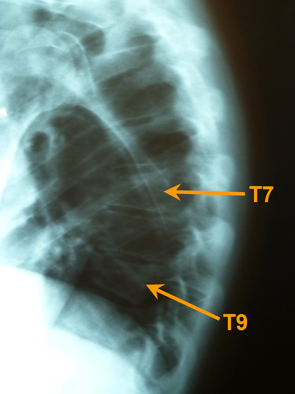
Interestingly, he noticed something else that had escaped his attention eight weeks ago.  It appears that I broke two vertebrae instead of just the one we previously noticed!  As you can tell in the image below, T7 has a wedge shape similar to T9, which is indicative of a compression fracture.

After (May 2012)
Fortunately, two broken bones are treated the same way as one, and my prognosis has not changed.  I'm grateful for noticeable progress in flexibility, strength, and comfort, although I suppose I'd agree that my back doesn't feel completely healed yet.

Before (2009)
For reference, I've included this image of that same portion of my spine three years ago.  If I hadn't seen my name on the x-ray film, I'd have a hard time believing my back looked this good!  Thanks to all who have been praying for my healing through this episode.

Saturday, June 2, 2012

More than you wanted to know about a bicycle crash

Since it's still pretty fresh in my memory, allow me to tell you a bit about the results of my carelessness on my bicycle.  I was enjoying a delightful bit of exercise last Monday evening, riding pleasant roads with enough elevation change to be interesting and yet not overwhelming.  A little over half way through my ride, I started down the hill near the west end of Tullamore Road, and looked forward to the rest it would provide for at least the next half mile until the effect of its slope would disappear.

Although I knew there was a fairly sharp corner about halfway down the hill, I neglected to brake until much too late.  By the time I reached the beginning of the turn it was apparent that I would not be able to brake hard enough to stay on the road.  My odometer indicated I reached 36 mph, which was probably just before I began braking.  My path took me to the far side of the right turn where I rode along the guard rail on the left side of the road for a short distance before I was catapulted.  The view of the guard rail below is similar to the last view I had before I closed my eyes.

When I stopped moving and opened my eyes, I was about forty feet further down the road, about fifteen feet down a grassy slope on the other side of the guard rail.  I couldn't see my bike, my helmet was falling off my head, and my back felt stiff just below my shoulder blades.  I climbed up the grassy slope to the road and sat on the guard rail while I tried to stretch my back and push the broken pieces of my helmet together so it would fit on my head.  Since my bike wasn't on the road, I concluded it must be near where I landed in the ditch, so I climbed back down the slope and found it about ten feet further downslope from where I landed.  After I carried it back up to the road, I was surprised to find everything intact on the bike (except the chain which had simply jumped off the chainring) and no damage evident anywhere.  Equally amazing to me was my observation that my only apparent missing skin was on a few fingers of my right hand.  My legs and arms had no cuts or abrasions at all!  After thanking God for preserving my transportation home, I climbed aboard and started down the rest of the hill toward home.

After riding about a half mile, something unfamiliar about my vision made me realize I had lost my glasses in the fall.  As long as there was a small chance I might find them, I had to go back and look.  I knew the probability that I would find the glasses was very low, so I entreated the Lord to bless my efforts and bring me to them.  I searched about half of the area where I had come to rest for about five minutes before the glasses were visible to me again.  God was thanked again.  Now that I had all my possessions, I climbed back on the bike and started the ride home again.

I didn't know the source of the stiffness in my back while I was riding, but it was apparent that I could not comfortably expand my rib cage as far as normal, so my breathing was not as deep as I desired.  X-rays taken by my chiropractor the next day allowed him to diagnose a compression fracture of my T9 vertebra, which is identified by the yellow arrow in the image above.  You can see that vertebra is not as square as the others around it, and is tapered toward the front.  Fortunately, the damage to the bone is concentrated toward the front of my body and not toward the back, and I have no symptoms indicating any damage to my spinal cord.  Several sources indicate spinal cord damage at this location can lead to paralysis below the waist.  Again, I'm grateful for God's mercy in limiting my injury.

It wasn't until I looked in a mirror when I got home that I realized my head was bruised and scraped in this colorful manner.  This picture was taken less than two days after impact, so the color is more severe in some places while less severe in others, but I think you get the idea.  My left shoulder showed similar bruising, and my left ear was pretty beat up, so it was apparent I probably first made impact with earth on those parts of my body.

Since my leg and bicycle showed no indication of contact with the guard rail, I believe the front wheel of my bicycle was probably stopped by some object on the ground while my momentum carried my body over the guard rail in a half flip, ultimately landing on my head.  Since my shoes were clipped to my pedals, I think my flying body must have pulled the bicycle over the guard rail behind me, and as I hit the ground and rolled, the bike must have detached from my shoes and flown over my body down the slope of the ditch.  I don't think my left foot released from the bike pedal easily, as my shoe and its cleat are both damaged in a manner that would suggest a lot of force was required to separate them.  I wish I could have witnessed all the gyrations my body and bike went through, as I think it would have been very interesting to watch.  Again, I'm grateful that God mercifully spared me contact with the guard rail, as I believe my injuries would have been more severe had I hit it.

This view of the inside of my helmet shows the cracks in the front (right side of the image) that resulted when the full weight of my hurtling body forced the helmet into the earth.  I had no dirt or grass stains on the front of my body after the fall, but once I removed my jersey at home, I could see it was covered with dirt and grass stain skid marks on the back.  That evidence suggests I may have quickly rolled on to my back and/or slid down the slope of the ditch primarily on my back.  Given the type of damage to my vertebra, I believe it happened when I first made impact with my head.

Four days after the crash, I returned to the scene to look for more evidence of what happened.  The video below documents a good bit of what I found.


Looking over the scene made me even more aware of God's mercy through this incident as there are plenty of objects I could have contacted that would have caused much more damage than what I suffered.  My chiropractor informs me that my vertebra will require 8 to 12 weeks to heal completely, which should be enough time to remind myself that carelessness sometimes has painful consequences.

Monday, May 16, 2011

A Springtime Survey of Our Property

We've been pleased with a few things of beauty around our yard over the last few weeks, and we would like to share them with all of you.

At the end of April, the almond bush exhibited more blossoms than we've ever seen on this bush. We transplanted it from a shady spot a couple years ago, and I think it likes full sun better than shade.


About the same time, the primrose plants were blooming in another area. These were also planted a couple years ago, and this was their best performance as well.


This is a typical branch on the cherry tree in late April. We were astounded to see so many blossoms after a big cherry harvest last year. Alas, by early May we experienced a freeze in our yard, and many of the potential cherries died. It looks like a limited crop of cherries this year.


I took this photo of the chives today. They've done well the last couple years, and it looks like they are almost ready to consume now.


I planted this new food crop in mid April as a rhizome, and I hope to find enjoyment in measuring the growth of at least six of these plants this summer. Can anyone identify it?


Last, but not least, is the neighboring property to the west where something was planted about a week ago. This photo was taken last Sunday, but there is nothing sprouting yet. Don't lose sleep worrying about this field, I'll provide all the details as the growing season progresses. Thanks for visiting!


Monday, February 21, 2011

February cycling -- Illinois style

My friend Tim in Pennsylvania posted a video on Facebook of a motorcycle ride he took last Friday in gorgeously uncharacteristic weather there. That prompted me to get out on the bike yesterday to enjoy the mild (55 F) weather here in Illinois. Although it was not as sunny and pleasant here as it was in PA two days earlier, it was still satisfying to enjoy the mild weather, and record the ride on video for Tim's, and your, benefit.


This was my first attempt at recording video while riding (I didn't have the luxury of having someone else do the filming), so I was disappointed that the wind noise makes it hard to hear what I'm saying. I'll leave it to our carefully observant readers to determine the full message I've left for Tim in the video. Give me your best guesses in the comments section.

Thanks for visiting!

Thursday, December 30, 2010

Further definition on the Google map challenge

At the end of the last post, I expressed hope that our neighbors had good records since I noticed something in the Google Maps images of our neighborhood that related to their activities. The image below is a wider view of a portion of our neighborhood (images courtesy of Google Maps, copyright 2010) that shows our house at the bottom left and two colored squares that denote the objects of interest.

I first noticed the object in the green square on the road, and quickly identified it as belonging to our neighbors. A closer view is shown below.

That's our neighbor's blue tractor pulling a grain wagon, that appears to be laden with corn. It's headed back to the grain bin, so the combine is probably not far away.

Here's a closer view of what's in the yellow box. Sure enough, that's their yellow combine making its way through the field in the valley. A check of their records indicates that field was harvested on October 5 and 6. In the image, the field appears to be less than half harvested, and the shadows seem to mark the time of day slightly before noon, so my neighbor's comment on the previous post that the image was taken at 11:03 AM on October 5th is probably as close as we'll get. With that knowledge, I think we can all sleep soundly now.

Tuesday, December 28, 2010

Deductions on the Google map challenge

Several readers have submitted insightful speculations on the date of the aerial photo currently describing our home on Google Maps. Since many of you probably don't know our yard as intimately as I do, I'll share my observations so we can try to narrow the photo date as closely as possible.

The "A" in the photo below identifies the teeter totter, which according to a previous post was placed into service on September 17. Unfortunately, I'm not able to tell from this image whether the upper level of the pivot is complete or not. On to the next clue.

The "B" on the left side of the photo designates the approximate location in the field that serves as our corn-measuring spot. Apparent in this photo, and even more apparent if you zoom out to see more of the cornfield, is the fact that the field has been harvested, and tilled. We know from another post that harvest happened on September 7 (which doesn't narrow the satellite image date), but we haven't noted in the blog when the tilling took place. We do, however, have a post about the second crop of corn that grew this fall, and a photo from September 27 that shows the field untilled. That helps, and we can narrow the photo to sometime between September 27 and December 16 when we first posted the Google Map image.

Moving on to item "C." Some readers noticed the absence of the gravel path from the house to the barn as described in another post. That post was dated November 11, but I know that the path was built the previous Saturday, November 6. That narrows the image down to about a 40-day window, Sep 27 to Nov 6, but I think we can do better than that.

Area "D" on the image locates a bare-dirt section of the yard that I tilled the same day Farmer Wagenbach tilled the big field next to us. As I recall, that was October 2. That day I was able to sow a bit of the grass seed on the south end of the dirt patch and immediately watered only that section. Over the next week, I eventually sowed all the grass seed, and began watering the entire patch. The Google Maps image appears to show damp earth only on the south end of the patch, so I think the image must have been taken sometime in that first full week of October, and at the latest, sometime in the second week. That's the best I can do with the data I have right now, but if my neighbors have good records, we might be able to narrow the date further. If so, you'll be the first to know!

Thursday, December 16, 2010

Google map challenge

Google Maps recently updated the image of our neighborhood as you can see below (image courtesy of Google Maps, copyright 2010, of course). A few things grabbed my attention as I looked at the image, such that I began to wonder if I could pinpoint the day the photo was taken. Can you?

Maybe you'll notice something I didn't, but there should be enough information in the photo and in previous blog posts to narrow the date range considerably. Leave your best guess in the comments area, and if you're familiar with our neighborhood, feel free to look for clues at the neighbor's houses also. Thanks for the help!

Sunday, September 26, 2010

Mystery in the Backyard, Update #2

In case you can't tell, the latest project in the backyard is a teeter totter. The official maiden voyage of this new toy was actually Sep 17 when a neighbor family joined us for dinner and an evening of teetering. Since then, the main beam was subjected to some weatherproofing and we added another level to the pivot.


This evening, more friends came over to help test this latest version. Here's Arrow and Anchor taming the beast while their siblings wait patiently.

The design is not yet complete, but still available for testing. Do I have any volunteers?

Thursday, September 16, 2010

Mystery in the Backyard, Update #1

Gretel and I have made some progress on the backyard project, not all of which is documented here.

The posts now have 1-3/8" holes drilled through them... aligned axially north and south if that matters to anyone.

Yep, looks like the holes are lined up close enough to accomplish their purpose.

And finally, a pipe that fits nicely right through the holes. This is really only half of the project, and the lesser complicated half for that matter. We've had several people correctly identify this object so far, but none of them identified it in the comments section. Can you guess what it is?

Saturday, September 11, 2010

Mystery in the Backyard

We've started a new project in the backyard, but you'll have to guess what it might be.

Tuesday, June 15, 2010

Don't look now...

... but I think I see the new trend in blog posts that's sure to spread quickly across the blogosphere, as evidenced here. Okay, now you can go look.


(Thanks, Elissa!)


Tuesday, March 23, 2010

The mystery is solved!

Finally some clear images to explain what the mystery is all about. Lily has been busy on a little project for the colonial me, and it is now ready for unveiling. The curls peeking out from under my hat in the image below are not the result of follicle fertilization, but Lily's first attempt at wig making. Actually it was more like wig manipulation, but I'll explain that below.

Lily worked hard since the first mystery post to get the wig ready for its debut at Liberty Day, but that plan was foiled when I forgot to pack a critical part of my costume: my breeches. So this is the first public viewing of the finished product. I had to adjust my hat a bit to accommodate the extra volume on top of my head, but I think we'll be able to make it work.

A "hats off" view so you can see a bit more of the wig. Please pardon the beard and mustache -- I know it's not period-correct, but I wasn't motivated enough to shave it off for just a few photographs.

Here's a rear three-quarter view so you can appreciate the side curls and the pony tail complete with ribbon bow.

This is what we started with (and what appeared in that first Bigfoot-esque mystery photo). This is obviously a different color, but the same brand and style: the Lacey Deluxe Showgirl! The online store selling the wig says it makes a fine Miss Piggy, Mae West, Mona Lisa, Ivana Trump, and others, but they don't mention middle-aged colonial gentlemen. Go figure. I guess they don't have much imagination.

Friday, March 12, 2010

High-Tech Mystery-Solving Assistance

It's a good thing we have computers and the internet to help us solve the mysteries that spring upon us. I found GazoPa, a "similar image search" engine that tries to match all the images on the internet with an image that you upload. Desperate for help in solving our mystery, I gave it a try. There are literally thousands of images that share some similarity to our mystery photo, ranging from scenic shots to x-ray photos to portraits. These two seem to be the most likely matches:

This first one is Dmitri Mendeleev (try wikipedia if you don't remember him from your chemistry studies).

The second is a statue of Vladimir Lenin (if you must, you can also learn about him at wikipedia). Do these images have anything to do with our mystery photo? If they do, what is the connection? Is there another image on the internet that gives us more insight into this mystery? So many questions.... but so few answers.